GUO Huadong1,2, Zeeshan Shirazi1, LIANG Dong1,2, LIU Jie1,2
1 Institute of Remote Sensing and Digital Earth, Chinese Academy of Sciences, No. 9 Dengzhuang South Road, Beijing 100094, China
2 College of Resources and Environment, University of Chinese Academy of Sciences, Beijing 100049, China
During the first decade of the 21st century, global support for major international frameworks, such as the Sendai Framework for Disaster Risk Reduction and the Paris Agreement on Climate Change, and the Sustainable Development Goals (SDGs), represented international consensus on reducing mortal and economic risks and vulnerabilities of human populations around the world. These risks were recognized to be a consequence of modern development, environmental degradation, natural disasters and global climate change. These frameworks are oriented towards reducing and reversing anthropogenic effects on the ecology and climate and towards adopting a more green and sustainability driven development approach. The Digital Belt and Road Program (DBAR) was initiated to aid implementation of these international frameworks in the aspects of science, technology and innovation in the Belt and Road region. DBAR aims to develop a platform to share expertise, knowledge, technologies and data to demonstrate the significance of Big Earth Data in support of these global frameworks, promoting data- and technology-aided policy development and solutions to regional and global problems. DBAR strives for smart utilization and application of Big Earth Data in the design, development and implementation of diverse projects related to infrastructure improvement, environmental protection, disaster risk reduction, water resource management, urban development, food security, coastal zone management, and the conservation and management of natural and cultural heritage sites.
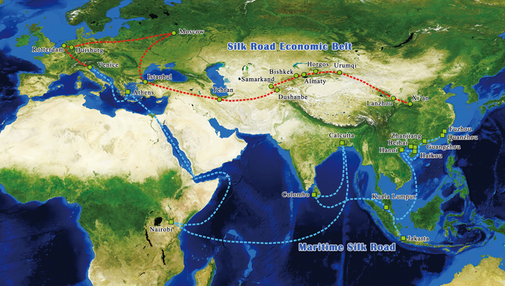
Figure 1. The Belt and Road Initiative represents China’s progressive vision for economic and developmental cooperation between countries, regions, and organizations spanning the historical Silk Road
Introduction
The Belt and Road region, stretching from China across Asia to parts of Europe and North Africa, covers an area with a large population and represents diverse ecosystems with distinct characteristics, environmental stresses and ecological vulnerabilities. The varying levels of development convolute the mortal and economic vulnerabilities of the regional population. Additionally, administrative divisions create policy demarcations for shared resources and mutual problems, complicating policy development, decision making and mitigation strategies. For example, management of water resources, air pollution mitigation and coastal ecosystem management are complicated processes in one part due to the complexity of the underlying natural processes and in another due to the administrative divisions of these resources between multiple nations. DBAR believes that science and technology will provide support to resolve complex policy and management issues and facilitate decision-making based on sound data and verifiable scientific results in the Belt and Road region. Through regional and global cooperation, DBAR aims to exploit multi-scale and multi-temporal data highlighting the utility of Big Earth Data to aid global frameworks. In essence, DBAR, like China’s Belt and Road Initiative, draws on the spirit of cooperation and seeks collaboration at multiple scales from regional to local, and from public to private sectors.
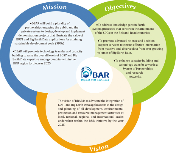
Figure 2. Vision, Mission and Objectives of DBAR (EOST: earth observation science and technology).
DBAR will address two broad challenges:
The inherent gaps in scientific knowledge on the Earth system processes determining responses of terrestrial, freshwater, coastal and marine ecosystems to global climate warming and environmental changes; and
A demand for hitherto unprecedented levels of cooperation between academic, policy and numerous other stakeholder communities for the integration of science and technology in the design, development and execution of international cooperation programs and projects for sustainable development.
The DBAR Foci are centered on Big Earth Data and interconnected through broad theoretical concepts. The Foci cover areas where the effects of climate change are more pronounced, including two key comprehensive regions, coastal and marine environments and high-mountain and Arctic environments. The areas of interest also encompass disasters, water resources, urban activity, infrastructure, heritage, and agriculture. However, Big Earth Data is the focus of DBAR’s data-centric solutions to the research and development challenges in the Belt and Road region (Figure 3). DBAR has established seven Working Groups to address individual Foci, namely Big Earth Data (DBAR-DATA), Agriculture and Food Security (DBAR-AGRI), Coastal Zone (DBAR-COAST), Environmental Change (DBAR-ENVI), Natural and Cultural Heritage (DBAR-HERITAGE), Disaster Risk Reduction (DBAR-DISASTER), and Water (DBAR-WATER), and two Task Forces (TFs) named Urban Environment (DBAR-URBAN) and High Mountain and Cold Regions (DBAR-HiMAC). DBAR has designed a workflow that allows synergistic exploitation of multiple data streams by developing an integrated data processing and analysis system to extract effective information from the data streams (Figure 4).
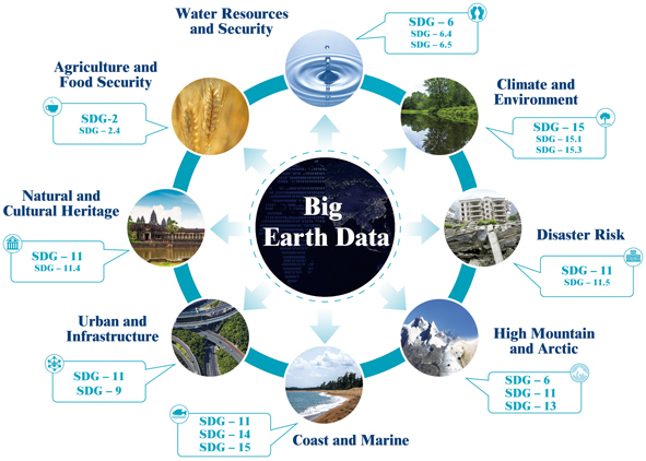
Figure 3. DBAR Foci
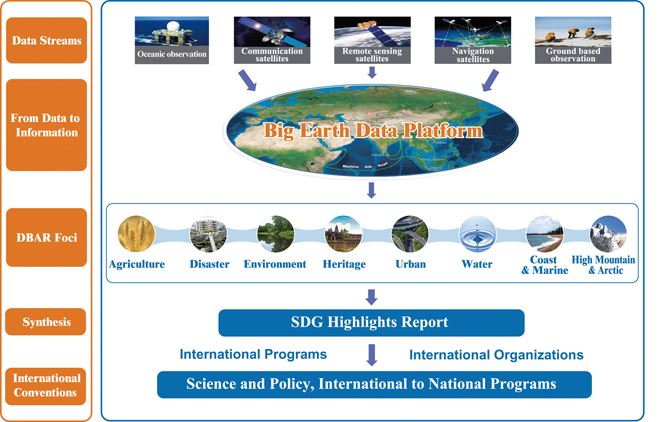
Figure 4. DBAR Workflow
Purpose and Significance
The global frameworks on climate, disaster and sustainable development encompass overlapping policy areas, providing a coherent framework for policy development, when taken as a collective. These initiatives provide guidance and global objectives for different issues at the macro scale, however, national and local scale policies, implementation guidelines and mechanisms are not explicitly addressed. This allows opportunity for varied solutions tailored for cultural, environmental and developmental diversity around the globe, employing human ingenuity towards their respective priorities and conditions. However, in spite of the flexibility provided in these international frameworks, there is a need to integrate action at larger scales especially for problems that expand beyond national boundaries and encompass multi-national interests. Realizing the need to promote collaborative approaches towards common global and regional problems, international stakeholders, following successes in rectifying international global frameworks, began deliberations to improve policy development facilitated by technology, including exploring mechanisms to incorporate EO technology. Earth observation data has become increasingly important with rising global trans-boundary problems such as global warming, intensification of disasters, ecological disturbances, resource management, environmental pollution, large-scale rapid land cover changes, and increasing global food and water insecurities. The consequence has been an increasing need and demand for EO data.
In the past few decades we have increasingly improved our ability to collect and digitize data, allowing us to understand complex natural phenomena. Earth observation data generation and quality has also improved along with other forms of geo-referenced data, allowing research into spatial and temporal aspects of different Earth systems and phenomena. Unfortunately, due to the large financial capital required, the number of countries producing quality Earth observation data for scientific applications is limited. The international science and Earth observation community has, in the last couple of decades, begun to increase the volume of freely available Earth observation data, easily accessible over the Internet. However, their utilization in context of these global frameworks is limited due to a lack of benchmark standards, methodologies and problems in data interoperability for data from difference sources.
In addition to procedural challenges, EO utilization in most of the Belt and Road countries is lacking due to capacity and human resource capability, hindering its integration in policy and decision-making processes.
The countries in the Belt and Road region are developing at different rates, inextricably influencing their research priorities, scientific infrastructure, and research methodology. EO therefore provides a unique opportunity to promote collaboration in science and research, through mechanisms of joint research capacity building projects, technology transfer and joint research centers allowing pooling of expertise of multinational researchers and experts.
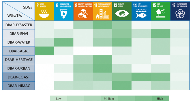
Figure 5 DBAR in support of the SDGs
In this perspective, DBAR holds a unique position not only due to its ambitions and objectives that target policy development with technology facilitation, but also due to its structure that is designed to facilitate policy development in the context of the developmental and economic conditions of nations, still in the developing class. One key mechanism that allows DBAR to be effective is to pursue experts in key scientific areas from a diverse range of backgrounds, and to combine multiple perspectives into solutions for regional and global problems. Both the cooperation to promote and develop skills and capacities in EO and the effective use of Big Earth Data for sustainable development will be key mechanisms of DBAR to build committed “people-to-people” relationships in the Belt and Road Initiative.
Progress
Since its inception, DBAR has defined milestones to ensure completion of its mandate within the defined program duration. Broadly, DBAR has three phases, with Phase 1 ending in 2018, marking the end of its preparatory phase and the beginning of its implementation phase. With a few months until the completion of Phase 1, targets identified are well on their way to completion. Details of these targets are explained as follows.
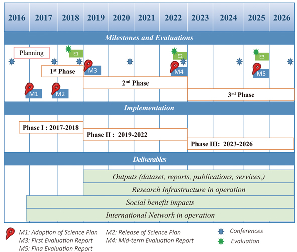
Figure 6. DBAR preparation and implementation schedule
Formation of the Science Committee (SC): The SC is the highest-level committee with responsibilities for overseeing and monitoring the progress and quality of the projects that are designed to implement the DBAR Science Plan. The SC ensures that DBAR conforms to good scientific practice in terms of data policy, quality, availability and stewardship. Within the first year of the program, a well experience and reputed committee was formed with experts from all over the world.
Formation of an International Secretariat: The Secretariat reports to the SC and is responsible for carrying out the day-to-day work and communication with all scientists, organizations, stakeholders and countries involved in DBAR. The DBAR Secretariat became operational in the middle of 2016.
DBAR Working Groups and Task Forces: Working Groups and Task forces are responsible for prioritizing and carrying out the activities outlined in the seven DBAR Foci. These working groups have a continually growing membership with new members expressing interest towards collaborative research.
Science Plan: Following wide consultation with the Earth observation community for over two years in a series of meetings in Asia and Africa, the DBAR Science Plan was formally released in December 2017. The Science Plan enlists the objectives and goals of the program including guidelines and the formal structure of administration with one clear destination, i.e., how to bring to fruition the huge data assets being accumulated in the Belt and Road countries to support progress towards sustainable development.
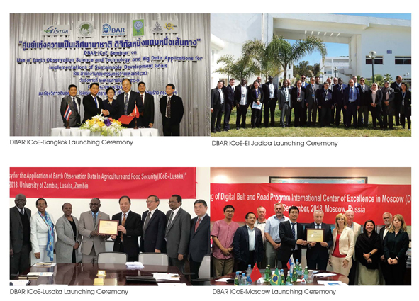
International Center of Excellence (ICoE): ICoEs represent DBAR’s vision to collaborate with different partners all over the world towards improving and implementing Big Earth Data research in policy development and for decision support in different countries. Presently the SC has approved eight ICoEs hosted in Peshawar, Bangkok, Helsinki, Potenza, Moscow, El Jadida, Lusaka and Columbia, out of which four have been officially inaugurated and have become operational, while the remaining four will likely become operational within the next few months.
DBAR Big Earth Data Platform: As one of the core projects of the DBAR Science Plan, the Big Earth Data Platform has received extensive research attention in the initial phases of DBAR. By the end of DBAR program, it is hoped that over 50 main data and knowledge products will be hosted on the online cloud platform. Currently about seven DBAR data products and over 90 TB of data are already available. The Big Data Service currently hosts six data types including Earth observation imagery, thematic products, vector files, geo-coded pictures, text files, and tables. It also hosts over 60 web map services and five web processing services. Officially the online platform will be inaugurated by the end of 2018 or early 2019.
International Cooperation and Collaboration
With rapid development and improving financial prosperity in the past three decades, China is increasingly developing its Earth observation capabilities in addition to its growing scholarship on Earth observation data from international partners for use in globally relevant studies. China has been extensively working on incorporating Earth observation in different scientific, social and management aspects of our society and is advocating the same for all the developing countries. China aspires to enhance cooperation with others through scientific diplomacy and considers big science projects an effective tool to solve key global scientific issues. DBAR also strongly advocates data sharing and has agreements with many international organizations.
DBAR and the Committee on Data (CODATA) of the International Science Council (ISC) ink an important Memorandum of Understanding (MoU), signifying consensus on cooperation between the two organizations at global and regional levels towards the development of Big Earth Data for use in sustainable development.
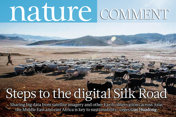
The comment article titled “Steps to the digital Silk Road” published by Nature in February 2018 identified five priorities for DBAR, including enhancing infrastructure; promoting data sharing and interoperability; extending applications to more people; identifying research opportunities; and, finally, strengthening international collaboration. Collaboration is vital in all of the preceding priorities. Therefore, international cooperation and collaborations are the foundations of DBAR, and correspondingly have led to strategic agreements between DBAR and international organizations.
On the 20th of September, 2017, Pan-Eurasian Experiment (PEEX) and DBAR sign an MoU to strengthen their cooperation.
An important Memorandum of Understanding (MoU) was signed between DBAR and the Committee on Data (CODATA) of the International Science Council (ISC), signifying consensus on cooperation between the two organizations at global and regional levels towards the development of Big Earth Data for use in sustainable development. The MoU promotes joint research on Big Earth Data in several thematic areas such as coastal zone resources, disaster risk reduction, agriculture and food security, environmental change monitoring, water and urban issues, and world heritage conservation. Together, they address issues of data interoperability and data integration that are major challenges to research in such interdisciplinary domains. Each organization agreed to development plans for future-oriented cooperation.
Another important MoU was signed on the 20th of September, 2017, between the Pan-Eurasian Experiment (PEEX) and DBAR to strengthen their cooperation, following mutual consensus on pooling their respective research resources for cooperation towards global sustainable development. PEEX is a multidisciplinary, multi-scale research initiative based in Helsinki, Finland, aiming at resolving the major uncertainties in Earth System and Global Sustainability Science concerning the Arctic and boreal Pan-Eurasian regions including the impact and influence of China. It is a bottom-up initiative by several European, Russian and Chinese research organizations and institutes.
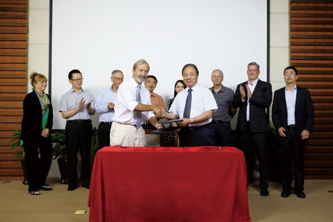
DBAR also developed an important partnership with the African Association of Remote Sensing of the Environment (AARSE). AARSE was incorporated as an international non-governmental organization in 2008. The primary aim of AARSE is to increase the awareness of African governments and their institutions, the private sector, and the society at large about the empowering and enhancing benefits of responsibly developing, applying, and utilizing the products and services of Earth observation systems and geo-information technology, an aim in tandem with DBAR’s vision. Both parties signed an MoU on the 26th of October, 2017, formalizing the agreement on employing spatial Earth observation for sustainable development of the Belt and Road.
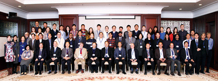
The 1st DBAR Conference held in Beijing in 2016
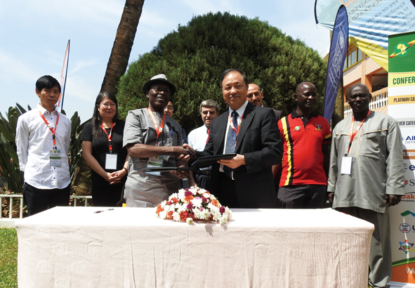
DBAR-HERITAGE and the Institute of National Heritage (INP) of the Culture Ministry of Tunisia signed a cooperation agreement in the embassy of the Republic of Tunisia in Beijing for cooperation on natural heritage projects in Tunisia in the future. Based on this agreement, a joint heritage research group between China and Tunisia was founded and planned to conduct field research about spatial archeology in Tunisia in December 2017. The cooperation agreement lays the foundation for DBAR to build towards cooperative research around North Africa and the Mediterranean region.
DBAR has successfully organized two international conferences, and in line with its tradition has scheduled the 3rd International Digital Belt and Road Conference in Tengchong City, Yunnan Province, China, from 5–7 December 2018. The conference will host several specialized sessions examining the applications of Big Earth Data for sustainable development in different fields, such as environmental change, disaster mitigation, water resources, food security, natural and cultural heritage, coastal and marine environments, urban areas and infrastructure, high-mountain areas and the Arctic, and the need for Big Earth Data in solving large-scale regional and global problems. The event will host experts and participants from a wide variety of public and private entities for improved partnerships and networking towards collaborative and collective efforts for regional sustainable development, through cooperation, sharing and integration of methodologies and data, and pooling of human and technological resources, as a model for global sustainability.
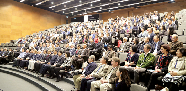
The 2nd DBAR Conference held in Hongkong in 2017
Conclusion
DBAR realizes the importance of Big Earth Data capability for national, regional and global climate and sustainability issues. It believes in developing solutions through sound scientific research and is therefore fully committed to international cooperation and data sharing. DBAR was initiated as a multidisciplinary science project to formalize data structures, analysis methodologies and develop cloud-based data analysis and sharing platforms towards a data-driven understanding of global problems. DBAR is also keen on developing technology to improve Earth observation data quality and research. DBAR believes that in the future it can play its role on the global stage in resolving problems, and hopes for increased cooperation with other partners in both developed and developing nations.